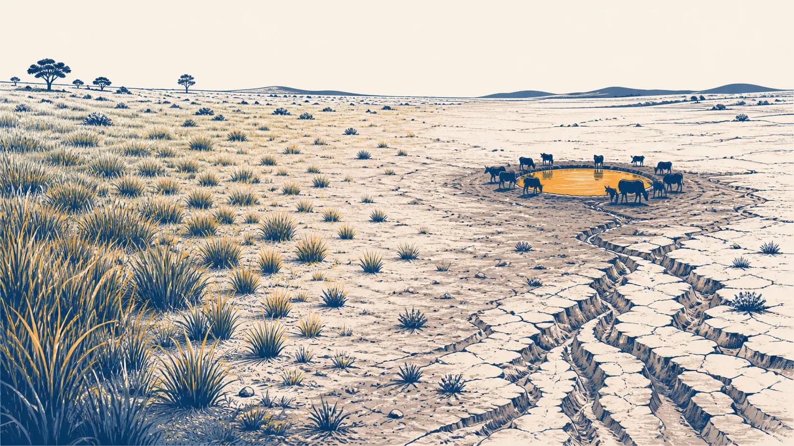
Desertification is a process of land degradation that reduces the biological productivity of drylands, in the context of physical geography and human land use. Put simply, it is the long-term loss of healthy soil, vegetation, and water function in dry places. The main causes of desertification include climate variation, repeated drought, overgrazing, deforestation, poor cultivation, and badly managed irrigation. Its effects include lower crop yields, less reliable grazing, dust, erosion, and greater pressure on water supplies. The concept exists because dryland damage is not explained by low rainfall alone: weather and human decisions interact.
What desertification actually is
Desertification is persistent land degradation in arid, semi-arid, and dry subhumid regions, caused by climatic variation and human activity. It means that land loses productive capacity and ecological function; it does not mean that every affected place becomes a sandy desert.
The internationally used definition comes from the United Nations Convention to Combat Desertification. Its wording matters because it separates three ideas that are often mixed together: the land must be in a dryland climate, the change must be degradation rather than ordinary seasonal variation, and both physical and human causes may contribute.
A dryland is a place where water demand is high compared with precipitation. Rain may be scarce, strongly seasonal, or unreliable from year to year. Meanwhile, sunlight, warm air, and wind can remove water from soil and plants quickly. These conditions do not make drylands useless. Grasslands, shrublands, farms, wildlife habitats, towns, and pastoral systems can all function well there. Desertification begins when damage reduces their ability to keep functioning.
Desertification is land degradation in drylands. A desert can be a stable natural ecosystem, while desertified land is land whose soil, vegetation, or water system has lost function.
The word productive also needs care. Productivity is not limited to harvested crops. It includes grass eaten by livestock, roots that hold soil, organisms that recycle nutrients, and vegetation that slows runoff. A field can still look open and brown during the dry season without being degraded. The stronger evidence is a lasting decline that continues across comparable seasons or recurs after each shock.
How desertification works
Desertification works through reinforcing losses: vegetation thins, bare soil receives more heat and impact from rain, water runs off instead of soaking in, erosion removes fertile particles, and plants then find it harder to return. Repeated pressure can lock the system into decline.
The sequence can start in several places. A long drought can reduce plant cover. Too many grazing animals can remove leaves faster than plants replace them. Repeated ploughing can break soil aggregates, while vehicles and hooves can compress wet ground. Cutting shrubs for fuel can expose the surface. Irrigation can add salt to the root zone. Each starting point changes the same connected system of soil, water, plants, and land management.
Leaves no longer soften raindrop impact, and roots no longer bind as much soil. Wind reaches the ground more easily.
Fine particles may wash or blow away. Trampling can close pores, and exposed surfaces can form crusts that admit less water.
More rain leaves as surface runoff or evaporates from exposed soil. Less remains in the root zone for the next dry period.
Plants produce less litter and fewer roots. Soil organisms receive less organic material, so aggregation and nutrient cycling slow.
Poorer soil supports less cover, and less cover exposes still more soil. Another drought or grazing season now causes greater harm.
These links are feedbacks, not an automatic one-way route. A short period of heavy grazing may be followed by recovery if animals move and rain arrives. A severe drought may leave little permanent damage where roots, seed banks, and soil structure remain intact. Desertification becomes more likely when pressure is frequent, recovery time is short, and the most fertile topsoil is physically removed.
Scale changes what a person sees. At the patch scale, the first sign may be bare ground around a water point. Across a slope, it may be rills cut by runoff. Across a catchment, streams may carry muddier floodwater for a shorter, sharper period after rain. Satellite images can reveal a regional pattern, but ground observations explain the process that produced it.
Desertification versus desert expansion
Desertification is the degradation of dryland, whereas desert expansion is a shift in the area or boundary of desert conditions. The two can occur together, but a degraded farm far from a desert edge can be desertified, and a moving dune is not automatic proof.
A desert advances like a single wall of sand, swallowing healthy land at its edge. If there is no dune, there is no desertification.
Damage often appears as scattered bare patches, eroded fields, salinized soil, or declining grass cover. These patches can spread and connect without any moving wall of sand.
Natural deserts are shaped by long-term climate, geology, water supply, and organisms adapted to dry conditions. They are not failed forests. Calling a natural desert degraded would confuse low biological productivity caused by the normal climate with a loss of productivity caused by land change.
Dunes also move naturally when wind transports loose sand. A dune crossing a road can be a serious hazard, but its movement alone does not establish desertification. Investigators ask where the sand came from, whether vegetation cover changed, what the previous land condition was, and whether the change is persistent.
Drought is another different idea. Drought is a temporary shortage of water compared with the usual conditions of a place. Desertification is a longer-lasting decline in land condition. Drought can trigger or expose degradation, especially where land is already stressed, but healthy dryland can recover after drought.
How climate and water pressure drive desertification
Climate drives desertification risk by controlling how much water arrives, how quickly it is lost, and how often plants face drought. Land management then determines whether soil stores scarce rain, sheds it as runoff, or loses it through bare-surface evaporation.
Rainfall total is only part of the story. Ten gentle showers can soak soil differently from one intense storm with the same total rainfall. When rain falls faster than compacted or crusted soil can absorb it, water moves downhill. It can cut channels, carry clay and organic matter away, and leave the field drier after the storm than the rainfall total suggests.
Potential evapotranspiration estimates the water that could evaporate from the ground and pass through plants if water were available. Comparing precipitation with this atmospheric demand gives an aridity index.
If annual precipitation is 400 mm and potential evapotranspiration is 1,000 mm, then , which falls in the semi-arid range used by the UN convention.
The United Nations Convention to Combat Desertification uses aridity index ranges to identify the drylands covered by its definition. Hyper-arid land falls below the convention's dryland scope, while the remaining bands run up to a ratio of 0.65.
A ratio is more informative than rain alone because the same rainfall can have different effects under different temperatures, winds, and seasons. It still does not diagnose degradation. It identifies the climate setting in which degradation would count as desertification. Analysts then need evidence of land condition and change.
Climate change can raise risk by altering heat, evaporation, rainfall timing, and the severity of some droughts. The outcome is not uniform across every dryland. Local soil, topography, vegetation, grazing rules, irrigation systems, and access to drought forecasts all affect what happens. The connections between air circulation and rainfall are explained further in the page on how climate systems create weather patterns.
How farming and grazing change the land
Farming and grazing cause desertification when the rate of plant removal, soil disturbance, or water extraction stays above the land's recovery rate. The activity itself is not the problem; timing, intensity, location, and repeated pressure decide the result.
Grazing animals eat leaves, which reduces photosynthesis until plants regrow them. Hooves can press seeds into soil and return nutrients through manure, so grazing can form part of a functioning grassland. Trouble develops when animals revisit the same plants before roots and leaves recover. Preferred grasses decline, less palatable plants spread, and paths around water points become compacted.
Cultivation exposes soil so crops can be planted. On dry, windy ground, leaving a field bare after harvest gives wind a long period to lift fine particles. Repeated tillage can also reduce stable aggregates and organic matter. Contour planting, crop residue, windbreaks, mixed rotations, and reduced disturbance can slow water and protect the surface, but their suitability depends on the farm.
Removing woodland or shrubs changes more than the number of trees. It removes root channels, shade, litter, and barriers to wind. Yet a blanket ban on cutting can miss how people actually use drylands. Managed coppicing, selective harvest, and agreed community access may protect regrowth better than rules that local households cannot follow.
Salinization can damage irrigated drylands
Salinization is the accumulation of soluble salts in soil at concentrations that hinder plant growth. Irrigation water naturally contains some dissolved minerals. Plants use water and evaporation removes it, but the salts remain. If drainage is poor or the water table rises, repeated irrigation can concentrate salt near the surface and around roots.
A farmer may respond to weak growth by adding more water. Without drainage, that can carry more salt into the field and raise the water table further. Effective management may require better drainage, carefully timed irrigation, salt-tolerant crops, or flushing salts below the root zone where water supply and downstream effects allow it. This is one reason land condition cannot be read from rainfall alone.
A field receives 20 mm of irrigation in a week, but only 14 mm leaves through crop use and evaporation while 2 mm drains below the roots. The remaining 4 mm adds to soil storage or runoff. Repeating this water balance without enough drainage can raise the local water table and bring dissolved salts closer to the surface.
Farm decisions also depend on prices, land rights, labor, credit, and security. A tenant with only one season guaranteed may have little reason to pay for terraces that take years to return the cost. A herder blocked from traditional dry-season pasture may be forced to keep animals near one water source. Physical geography explains what the soil does, while human geography explains why pressure becomes concentrated.
How desertification shows up in livelihoods and cities
Desertification shows up as unreliable harvests, weaker pasture, sediment-filled water systems, dust, and greater competition for productive land. Its effects move through food markets, household income, public health, infrastructure, and migration decisions rather than stopping at a field boundary.
For a pastoral household, the useful unit is not simply grass per square metre. It is access to different grazing areas across seasons, plus a route between them and dependable water. If fencing, conflict, or cultivation closes one route, animals may remain longer on the accessible land. A regional resource problem then becomes concentrated local degradation.
For a crop farmer, losing a thin surface layer matters because topsoil often holds much of the organic material, nutrients, seeds, and biological activity available to plants. Wind can carry the finest particles away first. The remaining surface may be coarser, less fertile, and less able to retain water. Lower yield can then push cultivation onto marginal slopes or shorten fallow periods.
Cities meet desertification through supply chains and catchments. Reservoirs and canals can receive eroded sediment. Dust can reduce air quality and visibility. Food prices may respond when a producing region has both drought and degraded land, though transport costs, trade rules, storage, and conflict also affect the final price. The page on how societies store and allocate water develops the catchment and supply choices behind these pressures.
Movement of people is rarely caused by one environmental factor. A household may send one member to a city after poor harvests, while another stays to manage land. Jobs, family networks, housing, borders, education, violence, and government support affect that choice. It is more accurate to say that degradation can increase pressure to move than to label every migrant a climate migrant.
The 1930s Dust Bowl in the United States is a well documented example of drought interacting with exposed cultivated soil and strong winds. It should not be treated as a universal model for every dryland. Its value is mechanistic: drought reduced cover, vulnerable soil was available, wind transported it, and farm households faced consequences far beyond the damaged fields.
How people measure and map desertification
People measure desertification by comparing land condition through time using vegetation, soil, water, erosion, and productivity indicators. No single photograph or satellite color proves the process; reliable assessment combines repeated observations with climate records, field checks, and knowledge of land use.
Satellites repeatedly measure reflected light from the ground. Healthy green leaves absorb much visible red light for photosynthesis and reflect strongly in near-infrared wavelengths. A common vegetation index uses that contrast. It can show changes in greenness across large areas, including places that are costly to survey on foot.
If near-infrared reflectance is 0.50 and red reflectance is 0.20, then . The result is meaningful only when compared with suitable seasons, surfaces, and field evidence.
Greenness is useful but ambiguous. A fallow field, a harvested crop, a drought-stressed grassland, and a permanently degraded patch can all appear less green. Rainfall can produce a temporary flush that hides poor soil condition. Irrigated crops may look green even while salt accumulates below. Analysts compare like seasons, account for rainfall, and examine trends rather than treating one image as a verdict.
Field teams can measure plant cover, species composition, infiltration, soil organic carbon, salinity, crusting, gullies, and the amount of ground protected by litter. Farmers and herders can identify changes in grazing value, spring flow, storm runoff, and recovery time that short field visits may miss. Good monitoring connects these observations to a clear baseline.
A simple erosion estimate is evidence, not a complete diagnosis
Suppose a rectangular plot 20 metres long and 10 metres wide loses an average soil depth of 1 millimetre after an event. The lost soil volume is . Converting that volume to mass would require a measured bulk density. The visible arithmetic makes the estimate checkable, but it still says nothing by itself about the long-term trend.
Maps also affect decisions. A national risk map can guide survey teams and public spending, but its broad pixels may miss a restored field or a damaged water point. A village map can record seasonal routes and local soil types, but it may not show regional rainfall change. Scale and purpose should be stated whenever a desertification map is used.
How restoration works
Restoration works by removing the pressure that caused degradation, keeping soil and water in place, and giving plants enough time and material to recover. The right method follows the local mechanism; planting alone will fail if grazing, runoff, salt, or insecure tenure remains unchanged.
The first task is diagnosis. If water runs off a crusted slope, stone lines or small earth structures placed along contours can slow it and encourage infiltration. If wind erosion dominates, residue, grass strips, shrubs, or windbreaks can reduce wind speed near the surface. If salinity is rising, the response must address drainage and water balance. One fashionable treatment cannot solve opposite processes.
Recovery can come from natural regeneration. Seeds already in the soil, surviving root systems, and resprouting stumps may establish plants better than imported seedlings. Protecting selected young growth from cutting and browsing can be cheaper and better adapted to local rainfall. Where seed sources are gone, active planting may be needed, followed by several seasons of care.
Grazing plans can rotate use, protect recovery areas, and preserve movement between seasonal pastures. Their success depends on agreed rules, workable boundaries, and water access. Excluding all grazing may shift animals onto neighboring land and worsen damage there. The management unit must be large enough to include the actual herd system.
Restoration also relies on biodiversity. Different root depths, growth seasons, and drought responses spread risk across a plant community. The relationship between climate, soil, organisms, and biomes is developed in the guide to how ecosystems and biomes function.
Count how many seedlings were planted on one day. This records an activity but not survival, soil protection, or benefit to land users.
Track surviving cover, infiltration, erosion, plant diversity, and agreed access over several wet and dry periods. This tests whether land function returns.
Success needs a reference condition, but the goal is not always to recreate an imagined untouched past. Climate, settlement, and livelihoods may have changed. A practical target might be a stable soil surface, reliable forage, safer runoff, and native plant recovery under present conditions. Monitoring should include possible harms, such as downstream water loss or the spread of an introduced tree.
4 mistakes people make with desertification
Four common mistakes are treating drought as permanent degradation, blaming one group in isolation, trusting a single green image, and assuming tree planting is a universal cure. Each mistake hides the interaction among climate, soil, water, vegetation, and institutions.
1. Treating every drought as desertification
Drought describes an unusual shortage of water over a period; desertification describes persistent loss of land function in a dryland. The distinction requires observations after rainfall returns. Fast recovery suggests temporary stress. Continuing erosion, poor infiltration, or lost perennial cover suggests lasting damage.
2. Blaming livestock or farmers without examining access
Animals and cultivation can contribute to degradation, but the explanation is incomplete without asking who can use which land, at what time, and under what constraints. A closed migration route, a new borehole, insecure tenancy, or a subsidized crop can change where pressure falls. Blame does not replace a causal map.
3. Treating temporary greenness as full recovery
Rain can produce annual plants that make satellite imagery greener for a season. Meanwhile, gullies may continue to grow and the perennial species valued for forage may remain absent. Recovery should be judged through several indicators and over enough time to include dry periods.
4. Assuming more trees always mean healthier dryland
Trees can trap sediment, shade soil, provide products, and support wildlife. The wrong species in the wrong place can consume scarce water, fail after planting, spread beyond the site, or displace open grassland habitat. The test is improved land function, not a high planting count.
Can desertification be reversed?
Desertification can often be slowed, halted, or partly reversed when the main pressure is removed before soil, seed sources, and water pathways are irretrievably altered. Recovery becomes harder where topsoil has vanished, deep gullies have formed, or salt remains concentrated.
Reversal is a matter of degree. Restoring ground cover and slowing runoff may happen before soil organic matter and plant diversity return. A field can regain useful production without becoming identical to its earlier ecosystem. Clear targets prevent the word restored from hiding which functions improved and which did not.
Prevention is usually less demanding than rebuilding a severely damaged system. Early signs include expanding bare patches, slower regrowth after grazing, sediment collecting behind fences, and water flowing off fields that once absorbed it. Acting at that stage protects the remaining roots, soil structure, and local knowledge.
Does planting trees stop desertification?
Planting trees stops desertification only where suitable trees address the actual cause and survive without creating new water or land-use problems. Many sites need grass recovery, grazing agreements, soil cover, drainage, or runoff control more than they need rows of seedlings.
A tree project should ask several concrete questions. Is the site naturally wooded? Are species locally adapted? Who protects seedlings and who may harvest them? Will roots compete with crops? Does the design reduce erosion at the relevant location? How many plants survive repeated dry seasons? These questions turn a planting event into land management.
Large shelterbelts can reduce wind speed downwind, while scattered trees can add litter and shade. In other settings, low stone barriers or retained crop residue protect more soil per unit of labor. Natural grasslands may store much of their carbon underground and support species that dense planting would displace. Form must follow ecological function.
The takeaway: Desertification is not a synonym for desert, drought, or sand. It is a measurable decline in dryland function, produced by linked changes in water, soil, vegetation, climate, and human decisions.
Desertification connects physical and human geography
Desertification connects physical geography with human geography because rainfall, evaporation, soil, and vegetation respond to grazing systems, property rules, markets, infrastructure, and public policy. Reading the land well means tracing both sets of causes at the same scale.
The next time a dry field, dust storm, grazing area, or restoration project appears in the news, check the evidence behind the label. Ask what the baseline was, how long the change lasted, which land function declined, and what mechanism links the proposed cause to the observed damage. Then ask who controls recovery time, water, movement, and investment.
Those questions are geographical because they connect processes across space and time. They also prevent easy stories from replacing evidence. The wider set of guides connecting physical and human geography shows how the same habits apply to hazards, cities, resources, climate, and ecosystems.