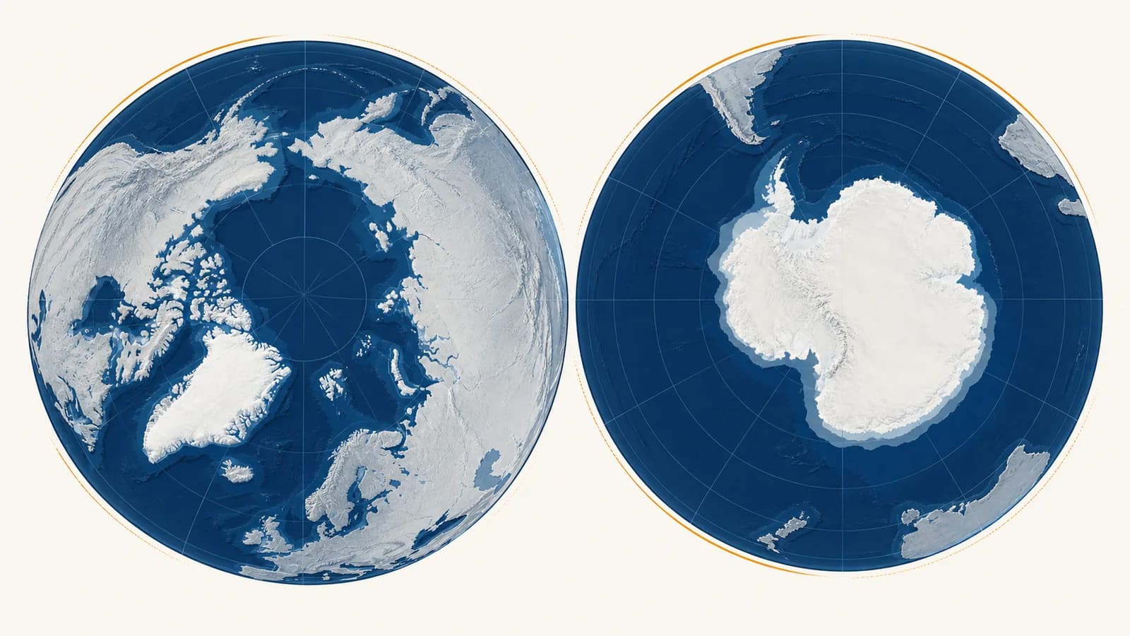
Arctic and Antarctic geography is the study of how land, ocean, ice, climate, living systems, and human activity are arranged and connected around Earth’s two poles. The Arctic and Antarctic regions are both cold, but the Arctic is mainly an ocean enclosed by continents, while Antarctica is a continent enclosed by ocean. Polar geography explains Arctic versus Antarctic climate, sea ice and ice sheets, polar day and night, wildlife, settlements, resources, and political control. The field exists because a map of ice alone cannot explain how these regions work or how changes at the poles affect weather, sea level, shipping, ecosystems, and decisions far beyond them.
What the Arctic and Antarctic actually are
The Arctic is a northern oceanic region whose boundaries vary by purpose, while the Antarctic is a southern continental region usually defined by Antarctica and the surrounding Southern Ocean. Neither region is simply a circular white area at the top or bottom of a map.
A geometric definition uses the two polar circles. The Arctic Circle lies at about 66.5 degrees north, and the Antarctic Circle at about 66.5 degrees south. Their exact positions shift slightly because Earth’s axial tilt changes over time. At least once each year, places poleward of a polar circle have a full day when the Sun does not set and a full day when it does not rise.
Physical geographers often use boundaries that follow environmental conditions instead. One Arctic boundary is the July 10°C isotherm, a line connecting places whose average July temperature is 10°C. Another is the tree line, beyond which climate and soil conditions prevent upright trees from forming forests. Those lines bend north and south with ocean currents, mountains, and continental climate. They do not match the Arctic Circle exactly.
“Antarctic” can describe the continent, its offshore islands, and the high latitude Southern Ocean. The Antarctic Convergence, also called the Polar Front, provides a biological boundary. There, cold northward flowing Antarctic water meets warmer subantarctic water. The meeting zone affects nutrients, plankton, and the distribution of marine species.
A boundary is a tool, not a wall. A latitude boundary is useful for sunlight, an isotherm for climate, a tree line for ecosystems, and a treaty boundary for law. Always ask what the map is trying to measure.
Arctic versus Antarctic
The central contrast is physical: the Arctic has a mostly ice-covered ocean surrounded by North America, Europe, and Asia, while Antarctica is a high ice-covered continent surrounded by ocean. That reversal shapes temperature, wildlife, settlement, access, and political geography.
Ocean at the pole, continents around it, seasonal sea ice, several sovereign states, long-established Indigenous communities, towns, roads, ports, and working economies.
Continent at the pole, ocean around it, a vast land-based ice sheet, no permanent Indigenous population, no ordinary towns, and research stations governed through international agreements.
Altitude strengthens the contrast. Much of the Arctic Ocean lies close to sea level. The Antarctic interior rises high above sea level because rock is covered by a thick ice sheet. Air pressure falls with height, and rising air expands and cools. Antarctica therefore combines high latitude with high elevation. Its land surface also lies far from the ocean’s moderating influence.
Ocean arrangement matters just as much. Northern continents partly enclose the Arctic Ocean, and rivers deliver freshwater into it. In the south, the Southern Ocean circles Antarctica with no continent blocking its path. Strong winds and the Antarctic Circumpolar Current move around the continent, limiting the transfer of warmer surface water toward the interior coastline.
| Feature | Arctic | Antarctic |
|---|---|---|
| Central surface | Ocean | Continent |
| Main floating ice | Sea ice on the Arctic Ocean | Seasonal sea ice around the continent and floating ice shelves attached to land ice |
| Land connection | Edges of three continents and many islands | One continent isolated by the Southern Ocean |
| Permanent population | Yes, including Indigenous peoples and other residents | No ordinary permanent population, only rotating station personnel |
| Large native land predator | Polar bear | None |
| Penguins | No native wild penguins | Several species breed in Antarctica or nearby islands |
The wildlife contrast follows food webs and evolutionary history, not a simple preference for cold. Polar bears depend heavily on Arctic sea ice as a platform for hunting seals. Penguins evolved in the Southern Hemisphere and did not cross warm equatorial waters to establish Arctic populations. Both regions support rich marine food webs, but the species and seasonal rhythms differ.
How polar sunlight works
Polar day and polar night result from Earth’s roughly 23.4 degree axial tilt, not from a large seasonal change in Earth’s distance from the Sun. Each pole tilts toward the Sun for part of the orbit and away for the opposite part.
The rotation axis points in nearly the same direction in space as Earth travels around the Sun.
During northern summer, the Northern Hemisphere receives longer daylight while the Southern Hemisphere receives shorter daylight. Six months later, the pattern reverses.
At sufficiently high latitude, Earth’s rotation carries the Sun around the sky without taking it below the horizon in summer, or above the horizon in winter.
Even in continuous daylight, sunlight reaches the surface at a shallow angle, spreads over a larger area, and passes through more atmosphere than tropical sunlight.
The circles can be derived from the tilt. If the axial tilt is approximately 23.4 degrees, the latitude at which a solstice can produce 24 hours of daylight is approximately:
The result is about 66.6 degrees north or south, with small variation as Earth’s tilt changes.
Day length alone does not determine heating. Snow and ice reflect much incoming sunlight. Low Sun angles reduce energy received per square metre. Some energy melts ice rather than raising air temperature. In winter, the surface loses heat during long darkness. The seasonal energy balance, not the label “midnight Sun,” explains polar temperature.
A research team at 70° north may have continuous daylight during part of summer, but it still plans around temperature, wind, glare, sea-ice movement, and wildlife. A clock says when to work. Sun position no longer provides the familiar signal for bedtime.
How ocean, land, and air create polar climates
Polar climates form through a linked energy system: weak sunlight limits heating, bright surfaces reflect energy, snow and ice cool the air, elevation cools Antarctica, and currents move heat toward or around the poles. Latitude starts the process, but geography controls its local result.
Water stores and releases more heat than land for the same temperature change. The Arctic Ocean absorbs heat in summer and releases some of it in autumn and winter, especially where open water remains. Coastal Arctic locations therefore tend to have smaller temperature ranges than continental interiors at similar latitudes. Deep inside northern Canada or Siberia, land can cool rapidly under winter darkness.
Antarctica’s interior is different. Thick land ice creates a high plateau, and the surrounding ocean cannot easily moderate its centre. Dense cold air drains downhill under gravity as katabatic wind. Where the terrain funnels that air, coastal winds can become fierce even without a passing storm.
This feedback is called ice albedo feedback. Albedo is the fraction of incoming light a surface reflects. Fresh snow has high albedo, while dark ocean and bare ground absorb more solar energy. When reflective cover shrinks, darker surfaces take in more heat. That extra heat can encourage further melting. The feedback amplifies an initial change, but it is one part of a larger climate system that also includes clouds, water vapour, winds, and ocean circulation.
Mountains and coastlines create sharp local differences. A mountain can force moist air upward, causing it to cool and release snow on the windward side. The descending air on the other side becomes drier. Fjords bring ocean water deep into Arctic land, while Antarctic ice shelves occupy embayments where coast shape and seafloor topography influence water movement beneath the ice.
Sea ice versus land ice
Sea ice is frozen ocean water that already floats, while glaciers and ice sheets form from compacted snowfall on land. Melting floating sea ice has little direct effect on sea level, but melting land ice transfers stored water into the ocean and raises it.
Sea ice forms when the ocean surface cools to its freezing point. Salt does not fit easily into the ice crystal structure, so much of it is expelled into nearby water as the ice grows. The rejected brine makes the water saltier and denser. Freezing, melting, wind, and currents constantly reshape the ice into leads, ridges, and moving floes.
A glacier begins when snowfall survives summer melting and is buried by later snow. Pressure gradually changes the buried snow into dense glacial ice. Under its own weight, the ice deforms and flows downhill. A continental ice sheet spreads outward from its thick interior. Where land ice reaches the coast and remains attached while floating, it forms an ice shelf.
It already displaces almost its own mass of seawater. The direct sea-level change is very small, though reduced sea ice changes albedo, habitat, waves, and coastal exposure.
Water previously stored above sea level joins the ocean. That adds ocean mass and raises average global sea level.
The floating-ice result follows Archimedes’ principle. A floating object displaces a mass of water equal to its own mass. A simple glass experiment demonstrates the principle: mark the water line with a floating ice cube, let the cube melt, and check the line again. Real seawater adds small complications because saltwater and meltwater have different densities, but the land-ice distinction remains the important one.
Do not use sea-ice area as a direct sea-level measure. Sea ice is climatically important, but changes in glaciers and ice sheets are the main polar ice contribution to sea-level rise.
Ice shelves matter indirectly. Because they float, their own melting adds little direct sea-level rise. Yet an ice shelf can slow the land glaciers feeding it, like a brace resisting outward flow. If the shelf thins or breaks apart, those glaciers can speed up, carrying land ice into the sea faster.
How polar maps work
Polar maps use projections centred near a pole because ordinary world maps stretch high latitudes severely. Every flat map distorts some combination of area, shape, distance, and direction, so the correct projection depends on the question being asked.
Longitude lines converge at each pole. On a rectangular Mercator map, those converging meridians are forced into parallel vertical lines, so scale increases toward the top and bottom. Antarctica may look like an enormous strip, while Greenland appears closer in size to much larger continents than it really is. The poles themselves cannot be shown on a standard Mercator projection.
An azimuthal projection places a pole at the centre and longitudes radiate outward. Direction from the central point can be shown accurately in some versions. An equal-area projection preserves comparative area, which helps when mapping sea-ice extent or habitat. A conformal projection preserves local angles and small shapes, which can help navigation, but area becomes distorted.
A planner needs bearings, distances, fuel limits, weather, landing sites, and magnetic conditions. A visually familiar rectangular world map is not enough. The projection and coordinate system must suit high latitude operations, and a route that looks curved on one projection may be close to the shortest path on the globe.
Location at a pole creates a naming problem. Every direction away from the North Pole is south, and every direction away from the South Pole is north. Longitude is undefined at the exact pole because all meridians meet there. Field teams rely on satellite positioning, grid systems, landmarks, and carefully defined bearings rather than treating the page edge as north.
Satellite images also demand interpretation. White may be cloud, snow, sea ice, glacier ice, or an ice shelf. Analysts compare wavelengths, surface texture, temperature estimates, movement over time, and coast outlines. Radar instruments can observe through cloud and polar darkness, making them especially useful for tracking ice motion and surface change.
How polar geography shows up in settlements, shipping, and resources
Polar geography shapes Arctic communities and Antarctic stations through ice, permafrost, seasonal light, and long distances. It also controls shipping and resource decisions through moving ice, shallow seas, limited ports, legal boundaries, and slow emergency response. Permanent Arctic settlement contrasts with temporary Antarctic research operations.
The Arctic is not empty. Indigenous peoples have lived across its lands and coasts for generations, with distinct languages, political institutions, and knowledge systems. Inuit homelands extend across parts of Alaska, Canada, Greenland, and Chukotka. Sámi homelands span northern parts of Norway, Sweden, Finland, and Russia. Many other peoples live across the Russian and North American Arctic. Their lives cannot be reduced to one culture or one traditional activity.
Permafrost is ground that remains at or below 0°C for at least two consecutive years. It may contain soil, sediment, rock, and ice. Buildings, roads, pipelines, and airstrips must account for ground movement. A foundation can transfer heat downward, thaw ice-rich permafrost, and cause uneven sinking. Engineers may elevate structures, insulate the ground, or use devices that remove heat from the soil.
Seasonal accessibility affects prices and schedules. Some settlements connect to regional centres by air throughout the year but receive heavy or bulky goods by ship during a short open-water season. Winter roads may use frozen ground and water, then close as conditions warm. A delayed freeze or early thaw can therefore alter construction, food delivery, medical travel, and household costs.
Local food systems mix store-bought supplies with fishing, hunting, herding, and gathering, depending on place and law. Changes in ice timing can affect safe travel and access to animals. The wider geographic questions of production, access, and stability connect polar communities to how geography shapes food security.
Antarctic stations solve a different settlement problem. Personnel rotate, waste and fuel require careful handling, and medical evacuation may be impossible during part of winter. Station design must cope with drifting snow, cold, wind, isolation, and limited resupply. Scientific work depends on logistics, so the geography of a safe runway or ice-capable harbour influences which observations can be made.
How shipping and resource use respond to polar limits
Polar shipping and resource decisions depend on changing ice, shallow seas, limited ports, environmental risk, legal boundaries, and long emergency response times. A shorter line on a globe does not automatically become a cheaper or safer route.
Great-circle routes are the shortest paths between points on a sphere. Many flights between northern cities arc toward the Arctic because that path is shorter than an eastward line on a rectangular map. Ships face additional constraints: ice thickness, ice movement, draft, straits, insurance, charts, escort availability, port capacity, and search-and-rescue coverage.
A northern route cuts sailing distance on the map, but the vessel needs ice capability and may wait for a safe passage window. The alternative is longer but has predictable ports and repair services. The decision uses total time, fuel, risk, cargo needs, fees, and emergency options, not distance alone.
Those tradeoffs are a polar example of how physical corridors shape trade routes. A strait can concentrate traffic, but concentration also creates a bottleneck. Weather, an accident, political restrictions, or ice can close the passage and shift traffic elsewhere.
The Arctic contains fisheries, minerals, and hydrocarbon resources, but physical presence does not make extraction sensible. Ore grade, distance to markets, construction costs, ice conditions, environmental damage, community consent, law, and commodity prices all affect feasibility. A resource is therefore an economic and political category as well as a geological deposit.
Under the United Nations Convention on the Law of the Sea, a coastal state may establish an exclusive economic zone extending up to 200 nautical miles from its baselines, subject to the convention’s rules. Rights to seabed resources can extend differently through continental shelf provisions. These are legal zones measured from coasts, not wedges owned simply because a country points north.
200 nautical miles is the maximum ordinary breadth of an exclusive economic zone under the law of the sea. It gives specified resource rights, not complete ownership of all navigation and activity.
Fishing connects ocean science to regulation. Managers need to know where species feed and spawn, how currents carry young organisms, and how warming or ice change shifts ranges. The same processes appear in the geography of oceans and coasts, where water movement links distant habitats and economies.
How political control differs between the poles
The Arctic is divided among sovereign states with established territories and maritime claims, while Antarctica is governed through the Antarctic Treaty System, which preserves peaceful scientific cooperation and manages competing claims without creating a normal sovereign state.
Eight states have territory north of the Arctic Circle: Canada, Denmark through Greenland, Finland, Iceland, Norway, Russia, Sweden, and the United States through Alaska. National laws apply within their territories. Indigenous governments and representative bodies also exercise authority in different forms, depending on the country and agreement. The Arctic Ocean includes internal waters, territorial seas, exclusive economic zones, continental shelves, and high seas areas.
Antarctica has no internationally recognized national government for the continent. Seven states have made territorial claims, some overlapping, while other states reject or do not recognize them. The Antarctic Treaty was signed in 1959 and entered into force in 1961. It applies south of 60° south latitude, sets Antarctica aside for peaceful purposes, protects scientific investigation, and leaves the legal positions of claimants and nonclaimants unchanged.
Twelve states sign the agreement after the cooperative research of the International Geophysical Year period.
Its peaceful-use, scientific, inspection, and claim provisions become operative.
The protocol designates Antarctica as a natural reserve devoted to peace and science and prohibits mineral resource activities other than scientific research.
Environmental impact assessment and detailed protection rules become part of Antarctic governance.
Scientific stations do not automatically create sovereignty. A country may operate a station within a claimed sector, but the treaty prevents that activity from strengthening or weakening a territorial claim while the treaty is in force. Researchers also inspect facilities, share plans, and cooperate across national programmes.
Political maps can conceal people as easily as they display borders. A line around an Arctic national territory does not show Indigenous land rights, seasonal use, language regions, or co-management agreements. Resource proposals can bring governments, companies, local residents, and environmental interests into conflict. Those interactions show how resource conflicts develop across places.
What lives at the poles and why?
Polar organisms survive by matching their bodies and life cycles to cold, light, ice, and seasonal food pulses. Most biological productivity is concentrated in oceans, coasts, tundra, and brief summers rather than the dark, dry interiors of permanent ice sheets.
Cold water can hold more dissolved oxygen than warm water, but light and nutrients still limit photosynthesis. In spring and summer, longer daylight allows microscopic algae to grow where light reaches open water or thin ice. Zooplankton feed on the algae. Fish, seabirds, seals, and whales connect the food web upward. Timing matters because a consumer must arrive or reproduce when its food is available.
On Arctic land, tundra plants remain low, reducing exposure to wind and using the warmer boundary layer near the ground. Shallow roots occupy the seasonally thawed active layer above permafrost. Mosses, lichens, grasses, sedges, dwarf shrubs, and flowering plants use the short growing season. Migratory birds and grazing mammals turn a brief summer pulse into movement, fat storage, and reproduction.
Antarctica’s ice-free land is limited, and the continental interior is extremely dry. Most large animal life depends on the ocean. Penguins, seals, and seabirds may breed on land or ice but feed at sea. Krill transfer energy from algae to many larger animals. Sea-ice timing changes the location of feeding habitat and the distance between colonies and open water.
Adaptation does not make organisms immune to change. A species may tolerate low temperature yet depend on a narrow breeding schedule or a particular ice type. If prey peaks earlier, snow covers a nesting site longer, or open water moves farther from a colony, the problem is geographic timing and distance as well as temperature.
How do scientists know what is changing?
Scientists measure polar change by combining repeated satellite observations with weather stations, ocean instruments, field surveys, ice cores, and local knowledge. No single record shows the whole system, so independent measurements are compared across space and time.
Satellites repeatedly map large remote areas. Passive microwave sensors can distinguish broad patterns of sea ice through cloud and darkness, although mixed surfaces near coasts require careful processing. Radar can measure ice movement and surface elevation changes. Laser and radar altimeters estimate height by timing a signal’s return.
In the ocean, moorings and autonomous floats record temperature, salinity, pressure, and currents. Ships collect water samples and map the seafloor. On ice, stakes and GPS units measure flow. Weather balloons observe the atmosphere above stations. Each instrument has limits, including drift, gaps, spatial coverage, and the difficulty of maintaining equipment in moving ice.
Sea-ice extent, glacier mass, snow depth, and surface temperature are different measurements and must not be treated as substitutes.
A consistent method builds a time series. Seasonal comparisons should match the same part of the year.
Field observations test satellite interpretation, while satellites show whether a local field site represents a wider area.
A measured change becomes more useful when winds, currents, snowfall, melt, or ice dynamics can account for it.
Ice cores extend evidence beyond the instrument period. Annual snowfall can trap dust, sea salt, volcanic material, and bubbles of ancient air. Scientists date layers and analyse their chemistry. Interpretation requires care because layer thinning, ice flow, and local snowfall affect the record.
Arctic residents contribute long records of travel conditions, animal behaviour, winds, currents, and sea ice. This knowledge is place-specific and built through repeated observation. Good research treats community knowledge holders as partners with rights and expertise, rather than as convenient sources of isolated anecdotes.
3 mistakes people make with polar geography
Most errors come from treating the poles as matching empty ice caps. The reliable correction is to separate ocean from continent, floating ice from land ice, and geometric boundaries from environmental or legal boundaries before interpreting a map or claim.
1. Assuming north and south are mirror images
The two poles receive opposite seasons, but their physical settings are reversed. The Arctic Ocean stores heat and connects to populated continental margins. Antarctica’s high continent is isolated by a circulating ocean. Similar latitude therefore does not produce identical climate or society.
2. Treating every white surface as the same kind of ice
Sea ice, glacier ice, ice shelves, snow cover, and frozen ground behave differently. Ask where the water came from, what supports the ice, and whether it moves. Those three checks reveal its direct role in sea level, habitats, travel, and ground stability.
3. Reading a flat map as a scale model of Earth
A projection can enlarge high latitudes, hide the shortest route, or make a legal boundary look physical. Check the legend, projection, scale, date, season, and boundary definition. A map is an argument built for a purpose, not a neutral photograph.
The takeaway: Start every polar question with four checks: ocean or land, floating or grounded ice, physical or legal boundary, and local observation or regional pattern. Those distinctions prevent most errors before calculation begins.
Polar geography connects the whole Earth
Arctic and Antarctic geography links latitude, climate, water, ecosystems, population, economics, and political power in unusually visible ways. Reading the poles accurately means tracing connections rather than treating them as remote white margins on a world map.
Notice the next polar image you encounter in a forecast, news report, shipping map, or wildlife film. Identify the season and projection. Decide whether the ice is floating or grounded. Look for the ocean current, settlement, law, or food web outside the frame. Then ask what measurement supports the caption.
The same habits apply across the wider set of geography topics and methods: define the region, identify the processes, compare scales, and connect physical conditions to human decisions. The poles make those habits easy to see because small errors about maps, boundaries, and ice lead to very different conclusions.