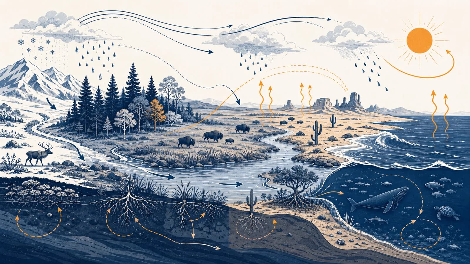
Ecosystems and biomes are geographic concepts that explain how living communities interact with climate, water, soil, and energy, in the context of physical geography. An ecosystem includes organisms and their physical environment; a biome groups large regions with similar climate and vegetation. The idea exists because life is not distributed randomly: temperature, rainfall, sunlight, nutrients, disturbance, and species interactions create recognizable patterns. Searching for ecosystem meaning, biome definition, types of biomes, food webs, or ecosystem examples leads to the same central question: what controls which organisms can live in a place, and what happens when one part of that place changes?
What an ecosystem actually is
An ecosystem is a functioning unit made of a community of organisms and the non-living environment with which they exchange energy and matter. Its size is chosen for the question being asked, so a pond, forest, rotting log, and whole river basin can each be an ecosystem.
The living, or biotic, parts include plants, animals, fungi, bacteria, and other organisms. The non-living, or abiotic, parts include light, temperature, water, air, minerals, soil, and physical space. An ecosystem exists through relations among these parts. A list of species is not enough. It must also include what those species eat, where they obtain nutrients, what conditions limit them, and how their activity changes the environment.
Consider a small pond. Algae capture sunlight. Insect larvae graze on algae. Fish eat larvae. Herons eat fish. Dead tissue and waste sink, where decomposers release mineral nutrients that producers can use again. Rain adds water, evaporation removes it, and runoff carries soil or fertilizer from the surrounding land. The pond therefore has inputs, stores, transfers, and outputs.
The boundary is practical rather than perfectly sealed. A pond exchanges water, heat, gases, sediment, and organisms with its surroundings. A geographer might draw the boundary around the water body to study oxygen levels, or around its catchment to study fertilizer runoff. The boundary must fit the process under investigation.
Habitat and niche describe different parts of the system
A habitat is the physical place where an organism lives. A niche is its way of living there, including the resources it uses, conditions it tolerates, and interactions it has. Two birds can share a woodland habitat while feeding at different heights and occupying different niches.
What a biome actually is
A biome is a broad geographic region defined mainly by long-term climate and the characteristic structure of its vegetation, together with the animals and other organisms adapted to it. Tropical rainforest, desert, temperate grassland, tundra, and boreal forest are common terrestrial biome categories.
A biome is a pattern at a larger scale than most ecosystems. Many distinct ecosystems occur inside one biome. The tropical rainforest biome, for example, contains rivers, tree canopies, forest floors, temporary pools, and clearings. Each has different local conditions and food webs, but all sit within a broad warm, wet climatic setting.
Biome maps simplify a continuous planet. Their borders vary among classification systems because researchers choose different temperature thresholds, rainfall measures, vegetation categories, and map scales. Mountains compress several climate zones into a short horizontal distance. Coasts, river corridors, and human land use also interrupt broad regional patterns.
Major terrestrial biomes reflect water and heat
Tropical rainforests remain warm and receive abundant moisture, supporting layered evergreen vegetation. Savannas have grasses with scattered trees and a pronounced wet and dry season. Deserts are limited by water, although they may be hot or cold. Temperate grasslands have seasonal temperatures and enough rain for grasses but often too little, or too much recurring fire, for closed forest. Temperate forests have marked seasons and sufficient moisture for trees. Boreal forests are dominated by cold-tolerant conifers. Tundra has a short growing season, low vegetation, and ground that may remain frozen below the surface.
Aquatic environments are often grouped by salinity, depth, water movement, light, and temperature rather than by land vegetation. Freshwater rivers, lakes, wetlands, estuaries, coral reefs, open ocean, and the seafloor differ enough that a single aquatic biome label can hide more than it reveals. The guide to how oceans and coasts shape places follows those marine controls in greater detail.
How energy moves through an ecosystem
Energy enters most ecosystems as sunlight, is captured by producers, passes through consumers and decomposers, and eventually leaves as heat. Because organisms use energy for maintenance, movement, growth, and reproduction at every transfer, less chemical energy remains available at higher trophic levels.
Plants, algae, and some bacteria are producers. Photosynthesis converts light energy into chemical energy stored in organic compounds. Herbivores obtain some of that stored energy by eating producers. Carnivores obtain some by eating other consumers. Detritivores and decomposers use dead material and waste, so decomposition belongs inside the food system rather than at its edge.
Photosynthesis builds energy-rich organic matter from carbon dioxide and water, using light as the energy source.
Feeding moves matter and chemical energy between organisms, but digestion is incomplete and respiration releases heat.
Fungi, bacteria, and detritivores break down dead material, obtaining energy and releasing nutrients into soil or water.
Energy dispersed as heat cannot be recycled into food, so ecosystems require a continuing energy input.
A food chain is one route, such as grass to grasshopper to frog to snake. A food web is more realistic because a species usually has several food sources and predators. If drought reduces grass growth, the effect can spread through several routes at once. Some grazers may decline, predators may switch prey, and decomposers may receive less fresh litter but more dead material.
If plants capture 2,400 energy units as gross primary productivity and use 1,500 in respiration, NPP is 900 units available for growth and consumption.
Gross primary productivity, or GPP, is the energy producers capture. Producer respiration, shown as R, powers their own cell activity. Net primary productivity, or NPP, is what remains as new plant biomass. It is the portion that can support herbivores, enter detritus, or accumulate as stored organic matter.
Energy flows, but matter cycles. Heat is lost from usable food energy at each transfer. Atoms of carbon, nitrogen, phosphorus, and water can be reused many times.
How matter cycles through living and non-living stores
Matter cycles when physical processes and organisms move chemical elements among the atmosphere, water, soil, rock, and living tissue. Unlike energy, atoms are not used up by respiration; they change compounds, locations, and availability as they pass through ecosystem stores and flows.
In the carbon cycle, photosynthesis moves carbon from atmospheric or dissolved carbon dioxide into organic matter. Feeding transfers it. Respiration and decomposition return much of it as carbon dioxide. Some carbon remains stored longer in wood, peat, soils, ocean sediments, carbonate rock, and fossil fuels. Combustion moves stored carbon into the atmosphere rapidly.
Nitrogen follows a different route. Most organisms cannot directly use atmospheric nitrogen gas. Nitrogen-fixing bacteria convert it into biologically useful compounds. Plants absorb inorganic nitrogen through their roots, animals obtain it through food, and decomposition returns nitrogen compounds to soil or water. Other bacteria can return nitrogen to the atmosphere. Fertilizer adds usable nitrogen, but excess can wash into water and stimulate algal growth. When algae die, decomposition can consume dissolved oxygen and stress aquatic animals.
A reservoir develops repeated algal blooms after heavy rain. Investigators map fields and drains in the catchment, test inflowing water for nutrients, measure oxygen at different depths, and compare bloom timing with rainfall. The ecosystem problem cannot be understood from the reservoir alone because the nutrient source may be kilometres upstream.
Water links atmospheric and terrestrial processes. Evaporation and transpiration move water vapour upward. Condensation and precipitation return it. Infiltration supplies soil water, percolation can recharge groundwater, and surface runoff connects slopes to streams. Vegetation intercepts rain, roots create pathways into soil, and leaf pores release water vapour. Removing vegetation therefore changes both the biological community and the movement of water.
The geographic questions of supply, storage, quality, and competing demand are developed further in the guide to water resources and their management.
Ecosystem versus biome
An ecosystem is a network of organisms and environmental processes at any useful scale, while a biome is a broad regional category based chiefly on climate and dominant vegetation. A woodland pond is an ecosystem; the temperate forest region containing it is a biome.
Defined by interactions and exchanges. It can be tiny or vast, and researchers choose a boundary suited to a process such as nutrient flow or predation.
Defined as a large-scale geographic type. Climate and vegetation give it a recognizable structure, although local ecosystems within it vary.
The distinction is one of purpose as well as scale. Ecosystem analysis asks how a system functions: where energy enters, which stores hold nutrients, and how a change spreads. Biome analysis asks why broad regions resemble one another and where their distributions shift across latitude, altitude, and continental position.
A biome is not the same as a habitat
A habitat belongs to the life of a particular organism. The underside of a desert rock can be habitat for an invertebrate, while desert is the biome. A single biome contains countless habitats, and one mobile species may use several habitats during feeding, breeding, and migration.
A biome is not the same as a climate zone
Climate helps create biomes, but the terms are not interchangeable. A climate zone describes long-term atmospheric conditions. A biome includes the living response, especially vegetation structure. Similar annual rainfall can support different vegetation if rainfall seasonality, soils, fire, drainage, or grazing differ.
How climate, soil, and disturbance create biome patterns
Biome patterns form because temperature and water set broad limits on plant growth, while soil, fire, flooding, grazing, and local terrain select among plants that can tolerate those limits. Vegetation then alters shade, wind, moisture, nutrients, and habitat for other organisms.
Temperature controls rates of biological activity and the length of the growing season. Water availability controls whether plants can keep cells functioning and stomata open while limiting water loss. Rainfall totals alone are insufficient. Rain that arrives in one short season creates a different challenge from the same amount spread across the year. Heat also raises evaporation, so a warm place can experience greater water stress than a cool place with similar rainfall.
Soils mediate the climatic signal. Texture influences drainage and water storage. Acidity and mineral content affect nutrient availability. Depth controls rooting space. Organic matter helps hold water and nutrients. A waterlogged soil lacks oxygen around roots, while a freely draining sandy soil may dry quickly. The interaction between soil formation and land use appears in how soil properties shape agriculture.
Disturbance is an event that removes organisms or biomass and changes resource availability. Fire can kill trees while opening space and returning mineral ash to the surface. Floods can uproot plants, deposit sediment, and connect isolated aquatic habitats. Grazers remove leaf tissue and redistribute nutrients in dung. Strong wind can create canopy gaps. Each disturbance has a frequency, intensity, area, and season, and those features matter more than the label alone.
Organisms also modify the controls acting on them. A tree canopy lowers light and wind near the ground. Roots stabilize soil and change infiltration. Decomposing litter alters organic matter and nutrient availability. Beavers dam flowing water and create ponds. Coral organisms build physical reef structure. The environment filters organisms, then organisms partly rebuild the environment.
How ecosystems show up in work and public decisions
Ecosystem knowledge guides decisions whenever people manage land, water, species, hazards, food, or pollution. Practitioners measure connections rather than treating each organism or site alone, because an action upstream, outside a reserve, or earlier in a season can cause the observed result.
Farmers manage a simplified ecosystem
A farm contains producers, consumers, decomposers, soils, water flows, and nutrient cycles. The farmer changes their proportions and timing. Crop rotation can interrupt pest life cycles. Flowering field margins can provide resources for pollinating insects and predators of crop pests. Tillage changes soil structure and exposes organic matter. Irrigation changes soil moisture and can move dissolved salts. Fertilizer supplies nutrients, but its timing and placement influence how much crops absorb and how much escapes.
Planners use catchments, corridors, and buffers
Urban planners and environmental engineers trace how rainfall moves across roofs, roads, drains, streams, and floodplains. Wetlands and vegetated areas can slow water, trap some sediment, and provide habitat, although their effectiveness depends on location, size, soils, and maintenance. Wildlife corridors can connect habitat patches, but a corridor useful to one species may be unsuitable for another. Design must begin with movement behaviour and habitat needs.
Conservation workers protect processes as well as species
Protecting one rare species may require safeguarding nesting sites, prey, pollinators, seasonal water, migration routes, and a suitable disturbance pattern. A fenced reserve can still be affected by altered river flow, smoke, disease, warming, or development beyond its border. Conservation plans therefore compare the species' life cycle with the spatial scale of each threat.
Restoration teams first identify what is preventing recovery. Planting trees will not repair every damaged site. Seed sources may be missing, but compacted soil, repeated grazing, altered drainage, contamination, or continuing fire can also block growth. The correct intervention targets the limiting process and includes monitoring that can show whether the system responds.
Public health teams track ecological connections
Disease risk can change when land use affects hosts, vectors, predators, and human contact. A useful analysis does not claim that biodiversity always increases or always decreases disease. It identifies the particular pathogen, its transmission route, the organisms involved, and the conditions that bring them together. The same process-based approach applies to allergens, harmful algal blooms, smoke, and contaminated water.
Four mistakes people make with ecosystems
Common errors treat ecosystems as fixed, sealed, balanced, or arranged in a simple ladder. Real ecosystems change over time, exchange material across boundaries, respond unevenly to disturbance, and contain branching food webs whose outcomes depend on species, timing, scale, and environmental conditions.
1. Assuming every ecosystem has a natural permanent balance
Populations fluctuate as weather, food, predation, disease, and migration change. Rivers shift channels. Fires create patches of different ages. Seasonal wetlands fill and dry. Stability can mean several different things: little variation, resistance to disturbance, rapid recovery, or persistence of function despite changes in species. A system may show one form and lack another.
2. Treating every introduced species as equally harmful
An introduced species occurs outside its native range because of human activity. An invasive species spreads and causes ecological, economic, or health harm under the definition used by the relevant authority. Many introduced species do not become invasive. Risk assessment asks how fast a species reproduces and spreads, what it consumes or competes with, whether local enemies control it, and which habitats are vulnerable.
3. Reading a food chain as a ranking of importance
Trophic level describes feeding position, not value. Producers form the energy base, decomposers make nutrients available again, and predators can alter prey abundance and behaviour. Removing a species can have a large effect if it performs a function with few substitutes, even when its biomass is small.
4. Believing one visible improvement proves recovery
Clearer water, more vegetation, or the return of one animal can be encouraging without proving that the system has recovered. Monitoring should match the original damage. Measures might include water chemistry, soil condition, vegetation structure, reproduction, species composition, and whether ecological processes persist across seasons. A short observation may miss delayed effects.
“The wetland looks green again, so restoration worked.”
“Native wetland plants survived, water remained at the target depth, and breeding animals returned across repeated seasonal surveys.”
The second claim can be checked because it names observations and a time frame. It may still need better targets, but it shows how ecosystem reasoning turns a visual impression into evidence.
How ecosystem boundaries and scales change an answer
Ecosystem boundaries and map scales change conclusions because different processes operate over different distances and times. A sample plot can reveal local plant cover, while a catchment reveals runoff sources, and a regional map reveals climate patterns that no single field site can show.
Suppose investigators find fewer aquatic insects in one stream reach. At the metre scale, shade and gravel size may explain where larvae occur. At the kilometre scale, an upstream discharge or barrier may matter. At the catchment scale, farming, roads, and rainfall control sediment and nutrient delivery. At the regional scale, drought may reduce flow across many rivers. All scales can be valid, but each answers a different question.
Counts of 4, 7, 5, and 8 plants in four equal quadrats give a mean of plants per quadrat.
The worked mean describes only the sampled quadrats. It does not prove that the whole site contains the same density. Reliable fieldwork uses a sampling design suited to the pattern. Random locations reduce selection bias. Systematic samples along a transect show change across a gradient. Stratified sampling ensures that distinct zones, such as shore, slope, and ridge, are represented.
Ecotones are transition areas, not failed boundaries
An ecotone is a transition between ecological communities or biomes. Grassland may grade into woodland as moisture, fire frequency, and soil change. Species from both sides may occur there, along with specialists in the transition itself. On a small-scale map, this broad mixed zone may appear as one sharp line.
Time scale matters too. A daily oxygen cycle in a pond, seasonal migration, recovery after a storm, and soil development unfold over different periods. A measurement taken at noon can miss low dissolved oxygen before sunrise, when plants and animals have respired through the night without photosynthesis adding oxygen.
How climate change and land use alter biomes
Climate change and land use alter biomes by shifting temperature and water limits, changing disturbance patterns, fragmenting habitat, and moving species at unequal speeds. The result is often a rearranged community rather than an intact biome sliding neatly across a map.
As climate conditions shift, species respond according to their tolerance, mobility, reproduction, and access to connected habitat. A mobile bird may change its seasonal range faster than a slow-growing tree population can move. Soil organisms and pollinators may respond differently again. Mountains create a hard spatial limit because organisms moving toward cooler, higher conditions eventually run out of land.
Land conversion can act more quickly. Clearing replaces layered vegetation with crops, pasture, buildings, or bare ground. Roads divide habitat and alter drainage. Dams change flow timing, sediment movement, water temperature, and access for migratory aquatic species. Extraction removes biomass or water. Pollution changes chemical conditions. These pressures interact, so the effect of drought may be greater in a fragmented or heavily used system.
A town plans development beside a salt marsh. A sound assessment maps expected inundation, sediment supply, roads, and higher ground. Protecting only the marsh's present outline may fail if rising water forces marsh vegetation landward but a seawall blocks that movement.
Managers use adaptation measures such as protecting climate refuges, reconnecting habitat, restoring natural water movement, reducing other stresses, and leaving room for shorelines or rivers to shift. Each measure needs a stated mechanism. A corridor is useful only if organisms can reach it and survive within it. A refuge matters only if the local conditions remain suitable.
Hazards can be part of ecosystem function and still threaten people. Fire, flood, drought, and storms become disasters through exposure and vulnerability as well as physical force. Understanding risk therefore requires evidence about ecological processes, exposed people and property, and the conditions that make harm more likely.
How biodiversity relates to ecosystem function
Biodiversity is variation in genes, species, and ecosystems, while ecosystem function is the movement and transformation of energy and matter. The two are related, but a simple species count cannot by itself reveal productivity, nutrient cycling, stability, or the condition of a place.
Species richness counts how many species are present. Evenness describes how evenly individuals are distributed among those species. Two sites can each contain ten species, yet one may be dominated by a single species while the other has similar numbers of each. Identity also matters because species perform different ecological roles.
Functional diversity groups organisms by traits that influence processes, such as rooting depth, body size, feeding method, nitrogen fixation, or tolerance of drought. If several species perform similar functions, one may partly compensate when another declines. Compensation is not guaranteed. Species that look interchangeable in one season or process may differ in another.
More species does not automatically mean better condition. A damaged site may gain widespread weeds, while a naturally species-poor bog or desert can be healthy and distinctive.
Field surveys therefore pair biological measures with environmental context and a reference. Investigators might compare native species composition, age structure, dead wood, soil carbon, water quality, or regeneration with an appropriate nearby site or with a defined management target. Historical conditions can inform the target, but future climate may make exact recreation impossible.
How people obtain benefits from ecosystems
People obtain food, water regulation, materials, climate regulation, recreation, and cultural meaning through ecosystem processes. Calling these ecosystem services can clarify hidden dependencies, but decisions must also address who receives each benefit, who bears each cost, and which losses cannot be replaced.
Provisioning services are products such as food, timber, fibre, and fresh water. Regulating services arise from processes such as pollination, water filtration, flood storage, erosion control, and carbon storage. Cultural services include recreation, identity, education, and spiritual connections. Supporting ecological processes, including soil formation and nutrient cycling, make many other benefits possible.
These categories overlap. A mangrove area can support fisheries, slow waves, trap sediment, store carbon, and hold cultural meaning. Converting it might produce a private return while increasing flood exposure or reducing access for other users. A complete appraisal identifies the affected groups, the time horizon, alternatives, and ecological thresholds rather than forcing every value into one price.
Resource decisions also involve renewal rates and extraction. A forest can regrow, yet harvesting faster than regeneration reduces its stock. Groundwater may recharge, yet pumping can exceed recharge for long periods. Fish populations reproduce, yet catches can remove breeding adults faster than the population replaces them. The distinction between a renewable stock and a finite resource therefore depends on rates, management, and scale.
Ecosystems make physical geography visible
Ecosystems make physical geography visible because living patterns record the combined effects of climate, water, landforms, soils, disturbance, and human action. Reading those patterns turns a map of biome colours into an explanation of processes, connections, limits, and change across space.
Start with any familiar place: a park, roadside verge, stream, beach, garden, or vacant lot. Identify producers, consumers, and decomposers. Notice where water enters and leaves, where sunlight is blocked, where soil stays damp, and what evidence shows disturbance. Then enlarge the boundary. Ask what comes from upstream, which organisms move beyond the site, and which decisions made elsewhere affect it.
This way of observing links a local patch to the wider study of geographic processes and places. The same habits apply at continental scale: define the unit, trace energy and matter, identify limiting conditions, compare scales, and test claims against evidence.
The takeaway: An ecosystem is a working network and a biome is a large-scale geographic pattern. To understand either one, trace the flows, name the controls, choose the right scale, and look for the process behind the visible pattern.