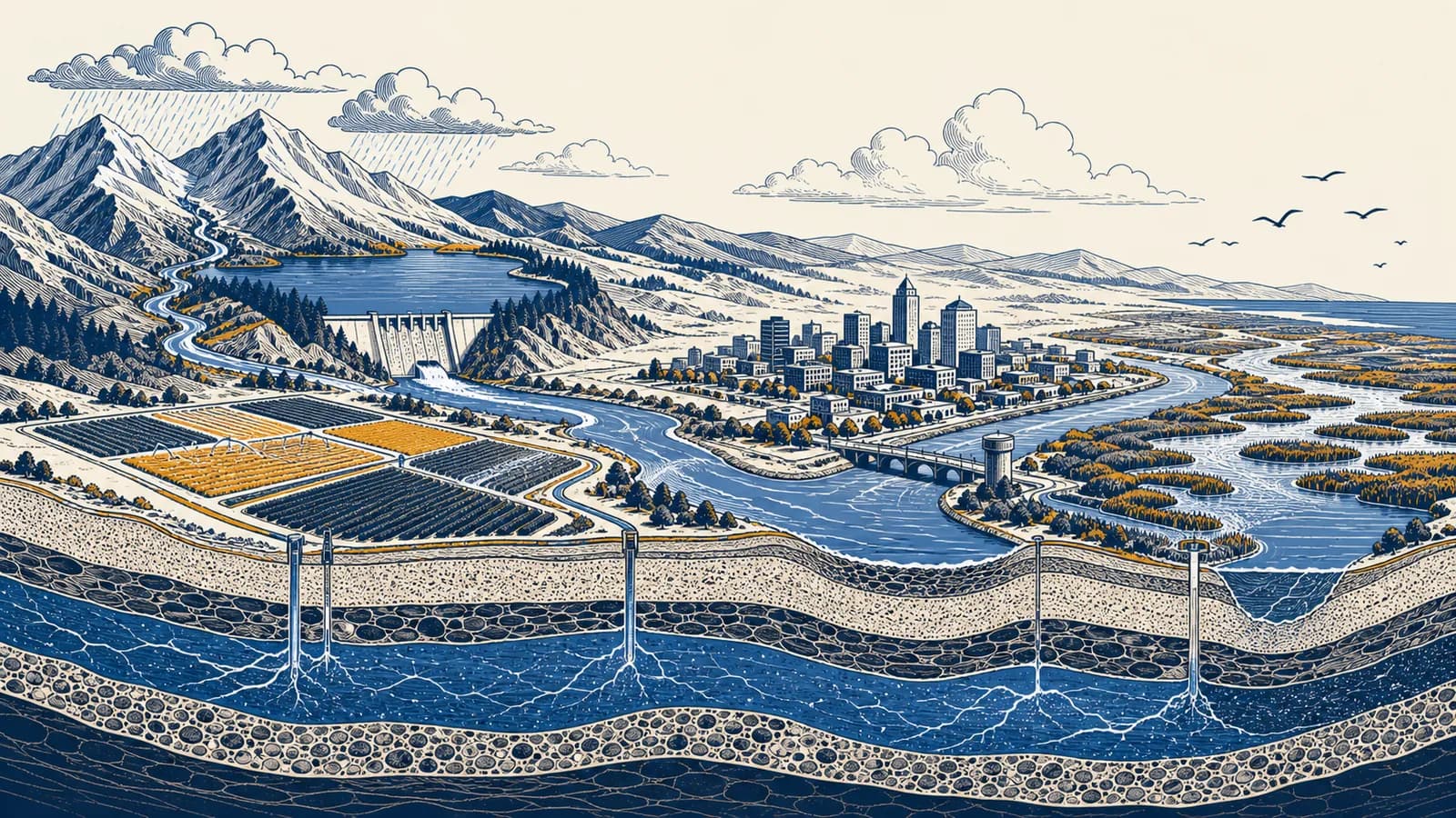
Water resources are natural and managed supplies that provide usable water for people and ecosystems, in the context of physical and human geography. The term covers freshwater sources such as rivers, lakes, glaciers, soil moisture, and groundwater, plus reservoirs, wells, pipes, and treatment systems that make water available. Water resource geography asks where water is stored, how the water cycle moves it, why water scarcity occurs, and how water quality limits use. The idea exists because water somewhere on Earth is not necessarily safe water in the right place, at the right time, for a particular need.
What water resources actually are
A water resource is a store or flow of water that has value for living systems or human activity. Its usefulness depends on quantity, quality, location, timing, accessibility, and the rate at which use changes the source.
The definition includes more than visible freshwater. A river is a resource because its moving water can supply habitats, farms, homes, transport, and electricity. An aquifer is a resource even though it lies underground. Rainfall becomes a resource when soil stores it for crops, a roof channels it into a tank, or a catchment feeds it into a reservoir. Wetlands also store water, slow floods, support wildlife, and can remove some pollutants through physical and biological processes.
Salt water is abundant but usually cannot be drunk or used on most crops without desalination. Polluted freshwater may exist in large volumes yet be unusable until it is treated. Ice in a remote polar ice sheet is freshwater, but location and form make most of it inaccessible. For this reason, geographers separate physical presence from effective availability.
These global proportions explain why the familiar picture of a water covered planet can mislead. The small share in rivers and lakes performs a large share of daily work because it is easier to reach. The much larger groundwater store becomes usable only where rock layers hold water and wells can reach it without excessive cost, contamination, or ecological damage.
A resource is relational. The same water can be useful for one purpose and unsuitable for another. Slightly salty water may cool machinery, yet damage a salt sensitive crop or fail drinking water standards.
How water moves between stores
Water moves through evaporation, transpiration, condensation, precipitation, infiltration, percolation, groundwater flow, and runoff. Solar energy lifts water into the atmosphere, gravity returns it to land and sea, and local geology controls the route and speed.
Start with incoming precipitation. Some rain or snow lands on leaves and evaporates before reaching the ground. Some enters the soil by infiltration. Plant roots take up part of this soil water, and leaves release it as vapor through transpiration. The combined return of water from surfaces and plants is called evapotranspiration.
Water that moves below the root zone percolates through pores and fractures. It may reach a saturated layer, where every connected space is filled with water. That water can travel slowly through an aquifer and later emerge at a spring, seep into a river, or enter a well. Water that cannot infiltrate, or arrives faster than the soil can absorb it, travels across the surface as runoff.
The flow paths operate at different speeds. Water may remain in the atmosphere for days, in seasonal snow for months, and in a deep aquifer for centuries or longer. A slow store can provide steady water during a dry season, but it also refills slowly after heavy pumping. The detailed movement of frozen water is developed in how glaciers store and release freshwater.
Land cover changes these routes. Paved streets reduce infiltration and send rain rapidly into drains and streams. Forest litter and root channels often promote infiltration, although the result depends on soil, slope, rainfall intensity, and previous wetness. Compacted farm soil can shed water even on a gentle slope. Geography therefore treats the water cycle as a set of connected processes, not a perfect circle with equal arrows.
How a water balance works
A water balance accounts for water entering, leaving, and remaining within a chosen area over a chosen period. It reveals whether storage is increasing or decreasing and prevents rainfall alone from being mistaken for usable supply.
For a drainage basin, the main input is precipitation. Outputs include river discharge and evapotranspiration. The difference appears as a change in storage in soil, snow, lakes, reservoirs, and groundwater. Human transfers can also add or remove water through pipelines, canals, pumping, irrigation, and wastewater discharge.
If a basin receives 900 mm of precipitation, loses 520 mm through evapotranspiration, and sends 300 mm away as river discharge, storage rises by 80 mm: .
Here, is change in storage, is precipitation, is discharge leaving the basin, and is evapotranspiration. All terms must cover the same area and time. Millimetres are useful because one millimetre spread over one square metre equals one litre.
The positive result in the example does not prove that every reservoir or aquifer filled. Storage might rise in snow while soil dries elsewhere. The yearly total can also conceal a summer shortage. A region could receive most of its rain during a few winter storms, lose much of it quickly to the sea, and face high demand months later.
Water managers use balances to test claims. A proposed irrigation scheme cannot sustainably withdraw more water merely because a large river passes nearby. The calculation must include seasonal flow, existing users, evaporation from canals, return flows, and the minimum flow needed downstream.
Surface water versus groundwater
Surface water occupies rivers, lakes, wetlands, snow, and reservoirs, while groundwater fills connected pores and fractures below the saturated zone. They differ in visibility and response time, but they usually exchange water and should be managed together.
Flow can rise within minutes or days after rain. It is easy to observe and divert, but open water is exposed to evaporation, runoff pollution, and sudden floods.
Flow through rock is often slower and less visible. Aquifers can buffer dry periods, but falling levels and contamination may remain unnoticed until wells or springs are affected.
An aquifer is not usually an underground lake. It is a body of permeable rock or sediment that stores and transmits useful quantities of water. Sandstone, gravel, and fractured limestone can form aquifers. Clay may store water in tiny pores but transmit it too slowly for a productive well, so it commonly acts as a confining layer.
The water table is the upper surface of the saturated zone in an unconfined aquifer. Pumping lowers hydraulic pressure around a well and creates a cone shaped zone of drawdown. If withdrawal continues faster than recharge and lateral inflow replace it, groundwater levels fall. Shallow wells may fail, pumping costs rise, springs weaken, and a connected river can lose flow to the aquifer.
Near a coast, excessive pumping can reverse the usual pressure gradient and pull seawater inland. This process, saltwater intrusion, can make wells too saline for use. The problem is not solved simply by drilling deeper because deeper layers may also be saline or may recharge very slowly.
A town pumps from wells beside a river during a rainless summer. River gauges show less water downstream even though no pipe draws directly from the channel. Pumping has lowered nearby groundwater pressure, so river water seeps through the bed toward the wells. The legal label “groundwater” does not remove the physical connection.
How water availability shows up in a drainage basin
A drainage basin is the land area whose runoff reaches the same river outlet. Its climate, relief, rock, soil, vegetation, and human infrastructure determine how much water arrives, how quickly it moves, and who receives it.
A watershed or drainage divide forms the basin boundary. Rain falling on opposite sides of a ridge can enter different river systems. Inside the boundary, smaller tributary catchments nest within larger ones. This makes the basin useful for analysis because an upstream action can be connected to a downstream result.
Climate sets the broad supply pattern
Precipitation provides most renewable freshwater on land, while temperature, wind, sunlight, and humidity influence evapotranspiration. A cold mountain basin may store winter precipitation as snow and release it during spring melt. A hot basin can lose a large share of rainfall to evaporation before it becomes streamflow.
Rock, soil, and relief route the water
Permeable rock encourages recharge and slower groundwater flow. Impermeable rock encourages surface runoff where fractures and thin soils cannot absorb much water. Steep slopes shorten the path to a channel, while broad floodplains temporarily spread and store high flows. The connection with how relief and landforms direct water explains why equal storms can produce different floods.
Infrastructure changes timing and ownership
A dam stores high flows and releases water later, but it also floods land, traps sediment, changes water temperature, interrupts animal movement, and increases evaporation from the new reservoir surface. A canal moves water across a natural divide. A levee protects one floodplain area yet may pass a faster or higher flood downstream.
Political borders rarely match basin boundaries. Several towns, provinces, or countries may share one river or aquifer. Upstream withdrawals can reduce downstream supply, while upstream pollution can transfer treatment costs to another community. Effective basin management therefore needs measurements, allocation rules, drought plans, water quality controls, and a way to settle conflicts.
A basin total can hide unequal access. Enough annual water on paper does not guarantee a reliable household tap. Distance, price, treatment capacity, legal rights, damaged pipes, and seasonal timing all affect who can use the supply.
How water resources show up in farms, cities, industry, and ecosystems
Water resources become visible through competing uses: households need safe supply, farms need soil water at specific growth stages, industry needs water of suitable quality, and ecosystems need enough flow, depth, temperature, and seasonal variation to function.
Farms manage water in the root zone
Irrigation supplements rainfall when soil moisture cannot meet a crop's needs. Flood irrigation spreads water across a field, sprinklers apply it above the crop, and drip systems deliver it near roots. None is automatically best. Performance depends on crop, soil, slope, wind, maintenance, energy, salt, and the skill of operation.
Irrigation water contains dissolved minerals. Plants take up water and leave much of the salt behind. If drainage is poor and evaporation is high, salt accumulates in the root zone and reduces plant growth. Applying extra water can flush salts downward, but only where drainage carries the saline water away. The relation between infiltration and crop production is developed further in how soils control farming choices.
Cities build a managed water cycle
A city captures water, treats it, stores it, distributes it under pressure, collects wastewater, treats that wastewater, and discharges or reuses it. Stormwater may use a separate drainage network. Leaks reduce delivered supply, while paved surfaces create fast runoff that can overwhelm drains and carry oil, litter, and sediment into rivers.
Intakes, wells, reservoirs, and catchment rules reduce sediment and contamination before treatment begins.
Drinking water treatment can combine screening, particle removal, filtration, and disinfection. The exact process depends on source quality.
Pumps, gravity, tanks, meters, pipes, and sewers move water while operators watch pressure, leakage, and contamination risks.
Wastewater plants remove solids, organic matter, nutrients, and pathogens to the degree required before discharge or reuse.
Drinking water quality and wastewater quality are different engineering targets. A factory may also need very pure water for a process, then produce wastewater containing heat, metals, oils, or chemicals. Good management matches treatment to the contaminant and the next use instead of treating all water as identical.
Ecosystems are water users, not scenery
A river's ecological condition depends on more than annual volume. Fish spawning may rely on a seasonal high flow. Floodplain trees may need occasional inundation. Cold water species can suffer if a shallow river warms after withdrawal. Environmental flow rules aim to preserve parts of the natural pattern, including low flows, floods, timing, and water quality.
These uses can support each other. A protected wetland can reduce flood peaks, trap sediment, provide habitat, and improve recreation. They can also conflict. Holding water behind a dam may secure dry season supply but remove the flood pulse needed by a downstream wetland. The decision requires an explicit account of gains, losses, and affected people.
How water quantity and quality are measured
Water quantity is measured as storage, flow, level, or change through time, while water quality is measured through physical, chemical, and biological indicators. Reliable decisions require repeated observations at meaningful places, not a single sample or annual average.
River discharge is the volume passing a cross section per unit time, commonly expressed in cubic metres per second. Hydrologists measure water level at a gauge and build a rating relation between level and discharge. The relation must be checked because erosion, sediment, plants, or construction can change the channel shape.
If the wetted cross section is and mean velocity is , discharge is .
Groundwater monitoring wells record hydraulic head, which indicates water level and pressure. Comparing levels across several wells shows the direction of groundwater flow. Rain gauges measure precipitation at points, satellites estimate conditions across larger areas, and soil sensors track moisture where roots can reach it. Every method has gaps, so several lines of evidence are often combined.
Water quality indicators answer different questions. Turbidity describes how suspended particles scatter light. Electrical conductivity gives a useful indication of dissolved ions. pH records acidity or alkalinity on a logarithmic scale. Dissolved oxygen helps show whether aquatic organisms can breathe and whether decomposition is consuming oxygen. Laboratory tests can identify nutrients, metals, pesticides, or disease causing microorganisms.
A concentration is not enough on its own when calculating pollution moving downstream. Load combines concentration with flow. A river can carry a large pollutant load at a modest concentration if discharge is high. During low flow, the same discharge from a wastewater pipe may create a higher river concentration because there is less water for dilution.
How scarcity, drought, floods, and pollution differ
Scarcity is a continuing mismatch between usable supply and demand, drought is an unusually dry condition relative to a local norm, floods occur when water covers normally dry land, and pollution makes water harmful or unsuitable for a use.
Physical water scarcity occurs where accessible water cannot meet desired use without depleting stores or damaging ecosystems. Economic water scarcity occurs where water exists but finance, institutions, treatment, energy, or infrastructure prevent reliable access. Both can occur in the same place. A settlement beside a polluted river may face scarcity of safe water, not scarcity of water molecules.
Drought develops in stages that do not always coincide. Meteorological drought is a precipitation deficit compared with the local record. Agricultural drought appears when soil moisture cannot meet plant needs. Hydrological drought affects rivers, reservoirs, and groundwater, often after a delay. A short rainstorm can end a run of dry weather without restoring an aquifer.
A drought, flood, or contamination event is a process with the potential to cause harm.
Damage depends on exposure and vulnerability as well as the hazard. A flood on an empty floodplain is not the same event as equal water depth in a dense settlement.
Pollution can come from a pipe, called a point source, or from widespread runoff, called a diffuse source. Excess nitrogen and phosphorus can stimulate algal growth. When algae and other organic matter decompose, microorganisms consume oxygen, which can stress or kill aquatic animals. Treatment at one pipe may be straightforward; reducing diffuse farm or street runoff requires changes across a catchment.
Flood and drought management can pull in opposite directions. Keeping a reservoir low creates room to capture a flood, while keeping it full secures supply against drought. Operators use forecasts, operating rules, monitored storage, and acceptable risk to choose releases. No setting removes uncertainty, because the next sequence of rain is not known perfectly.
Four mistakes people make with water resources
Common errors treat water as a fixed global total, confuse renewable flow with unlimited supply, ignore links between sources, or measure success only by engineered capacity. Each mistake disappears once location, time, quality, and affected users are included.
1. “The water cycle means water cannot run out”
Earth retains nearly all of its water, but a local usable source can still fail. Pumping can lower an aquifer faster than recharge replaces it. Pollution can remove a river from use. Snow can melt before demand peaks. The global cycle does not guarantee local renewal on a human timescale.
2. “Renewable means unlimited”
A renewable resource is replenished by an ongoing process, but use can exceed the replenishment rate. A river is renewed by runoff and groundwater inflow, yet withdrawing most of its dry season flow can damage ecosystems and downstream supplies. Renewal describes a rate and process, not a promise of endless supply.
3. “Saving water in one place always saves it for the basin”
Field efficiency and basin savings are not identical. Water that drains below an irrigated field may recharge an aquifer, and runoff may supply a downstream user. A more efficient system can reduce these return flows. It still brings benefits, but the basin effect must count where the old “losses” went.
4. “A larger dam or deeper well solves scarcity”
Infrastructure can shift water through time and space, but it cannot create rainfall. A larger reservoir may lose more water to evaporation and alter more habitat. A deeper well may tap slow recharge or saline water. Demand, leakage, allocation, quality, and ecosystem needs belong in the same decision.
The sentence is a reasoning test, not a claim that maps are unhelpful. Maps become useful when they show the relevant variables: seasonal flow, aquifer depth, salinity, treatment works, rights, prices, population, habitat, and connections between upstream and downstream places.
How can a water supply become more reliable?
A water supply becomes more reliable by combining source protection, diverse supplies, storage, efficient use, repair, reuse, fair allocation, and plans for extreme conditions. The best combination fits local climate, geology, demand, energy, cost, and ecology.
Source protection often reduces later treatment needs. Repairing leaks preserves already treated water. Metering can reveal abnormal use, while pricing and use rules can reduce waste if basic needs remain affordable. Rain tanks, reservoirs, groundwater, reused wastewater, and desalination can diversify supply, but each has limits and energy, land, or quality costs.
Reliability also depends on demand. A city can set different water quality targets for drinking, street cleaning, cooling, or irrigation. Treated wastewater may replace drinking quality water for some uses. During drought, staged restrictions can protect essential use before reservoirs reach emergency levels.
How desalination and water reuse change scarcity
Desalination and reuse can add dependable supply, but neither removes scarcity by itself. Both require energy, treatment, maintenance, finance, safe disposal or management of residues, and institutions able to deliver water without creating new health or environmental harm.
Reverse osmosis desalination pushes saline water through membranes that allow water molecules to pass more readily than dissolved salts. It produces freshwater and concentrated brine. Coastal plants need carefully designed intakes and brine discharge, while inland plants face a harder disposal problem. Reuse treats wastewater to a standard matched to its next purpose, sometimes including indirect or direct drinking water supply under strict controls.
These technologies change the supply calculation, not the geography. Energy price, coastline, elevation, pipe distance, public trust, regulation, and existing infrastructure still determine feasibility. A leak in the distribution network wastes desalinated water just as surely as reservoir water.
How shared water is allocated
Shared water is allocated through laws, permits, treaties, customary rights, prices, operating rules, and negotiation. A workable system defines who may use water, how much, under what conditions, and what changes when drought reduces the available supply.
Allocation is partly a scientific task and partly a public choice. Measurements can estimate flow, recharge, and ecological response. They cannot decide alone how to compare drinking water, food production, cultural sites, industry, or habitat. Those choices require transparent rules, representation, enforcement, and a way to revise decisions when evidence changes.
A reservoir holds less water than expected before summer. Operators present measured storage and inflow forecasts. Farmers describe crop timing, the utility states minimum household needs, and ecologists identify a flow below which fish habitat fragments. The decision is geographical because every option moves costs and water between places, seasons, and groups.
International rivers make the same issue visible at a larger scale. A rule based only on national demand can ignore downstream dependence. A rule based only on historic use can freeze old inequalities. Basin agreements commonly need data sharing, notice of major projects, procedures for drought, and a method for resolving disputes.
Water resources connect the physical and human sides of geography
Water resources show how climate, rock, soil, ecosystems, engineering, law, and inequality act on the same flow. Geography becomes practical here because every water decision has a location, an upstream cause, a downstream effect, and a timescale.
A useful way to read any place is to trace its water. Find the source of the tap supply, the boundary of its catchment, the route of wastewater, and the lowest ground where stormwater collects. Then ask what changes between a wet month and a dry one, who controls the infrastructure, and which ecosystems depend on the remaining flow.
The same questions connect this topic to the wider study of physical and human geography. They turn a river, well, field, reservoir, or street drain into evidence about processes and decisions rather than a feature to memorize.
The takeaway: Water is a usable resource only when quantity, quality, place, timing, access, and renewal line up. Follow those six conditions through a basin, and the causes of abundance, scarcity, conflict, and resilience become visible.